Category:Geophysical survey in archaeology
Jump to navigation
Jump to search
Media in category "Geophysical survey in archaeology"
The following 68 files are in this category, out of 68 total.
-
2016-10-12 Wiki final.webm 6 min 7 s, 1,920 × 1,080; 179.82 MB
-
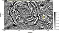
 3030-mag.jpg 516 × 466; 23 KB
-
 Aphrodisias-res.jpg 1,183 × 990; 132 KB
-
 Badania magnetometrem transduktorowym.jpg 1,536 × 2,048; 792 KB
-
 Badania metodą elektrooporową.jpg 1,536 × 2,048; 368 KB
-
 Badania metodą ERT.jpg 1,536 × 2,048; 598 KB
-
 Berlin Archäologische Sondierung Alex.jpg 2,180 × 1,816; 996 KB
-
 Bodenradar LBI-ArchPro.jpg 1,386 × 1,040; 506 KB
-
 Calvary depth slices.jpg 2,360 × 1,469; 368 KB
-
 Calvary line 23.jpg 470 × 426; 43 KB
-
 Empiracle Remote Sensing Analysis.svg 1,052 × 744; 777 KB
-
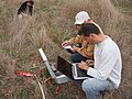
 EMsurvey.jpg 1,474 × 1,750; 671 KB
-
 FeldeinsatzFluxgatemagnetometer.jpg 6,000 × 4,000; 14.16 MB
-
 Ferrex DLG 4032.jpg 6,000 × 4,000; 11.64 MB
-
 Fluxgatemagnetometer.jpg 6,000 × 4,000; 21.54 MB
-
 Geofysisk arkeologi (3967956009).jpg 3,008 × 2,000; 4.3 MB
-
 Geofysisk arkeologi (3967956341).jpg 2,529 × 1,681; 4.23 MB
-
 Geofysisk arkeologi (3967956653).jpg 1,928 × 2,899; 3.85 MB
-
 Geofysisk arkeologi (3967956943).jpg 2,704 × 1,797; 3.24 MB
-
 Geofysisk arkeologi (3967957165).jpg 1,617 × 2,430; 3.25 MB
-
 Geofysisk arkeologi (3967957869).jpg 1,765 × 2,655; 3.89 MB
-
 Geofysisk arkeologi (3967958183).jpg 1,778 × 2,674; 4.09 MB
-
 Geofysisk arkeologi (3968730884).jpg 1,786 × 2,686; 3.71 MB
-
 Geofysisk arkeologi (3968731808).jpg 1,899 × 2,856; 4.73 MB
-
 Geofysisk arkeologi (3968732064).jpg 2,829 × 1,881; 3.8 MB
-
 Geofysisk arkeologi (3968732360).jpg 2,629 × 1,748; 4.58 MB
-
 Geofysisk arkeologi (3968732730).jpg 2,459 × 1,635; 3 MB
-
 Geofyzikalni mereni.png 489 × 491; 402 KB
-
Geophys at Pembroke Castle.webm 15 s, 1,280 × 720; 5.75 MB
-
 Gpr-cemetery-mapping.jpg 720 × 540; 321 KB
-
 Grabungsflächen LBI-ArchPro.jpg 2,338 × 1,654; 1.99 MB
-
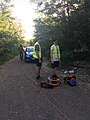
 Ground Penetrating Radar in use.jpg 2,600 × 1,950; 1.79 MB
-
 Ground radar search for Stockholm 1897 (4681563499).jpg 1,772 × 1,329; 454 KB
-
 Heisterburg Georadarmessung Computer.jpg 792 × 636; 510 KB
-
 Heisterburg Georadarmessung Wall.jpg 1,029 × 727; 655 KB
-
 Kastell-Buch-magnetic-surveyor.JPG 1,600 × 1,200; 378 KB
-
 LINE21.jpg 1,000 × 690; 102 KB
-
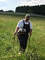
 Mag survey g858grad.JPG 1,024 × 1,280; 309 KB
-
 Magnetic image of council circle.jpg 600 × 335; 142 KB
-
 Magnetic image of effigy mound efmo hrs fig18.jpg 450 × 282; 27 KB
-
Magnetometerprospektion2.webm 6 min 8 s, 1,920 × 1,080; 49.26 MB
-
 Magnetprospektion.jpg 6,000 × 4,000; 12.16 MB
-
 Magnometer Prospektion Feld hinten.jpg 1,184 × 862; 1.54 MB
-
 Magnometer Prospektion Feld vorne.jpg 1,341 × 899; 1.59 MB
-
 Motorized gpr.jpg 1,200 × 828; 868 KB
-
 Night-time vertical aerial thermogram of a former kiln site.jpg 800 × 598; 489 KB
-
 Pomiary magnetometrem transduktorowym.jpg 960 × 720; 147 KB
-
 Pomiary metodą elektrooporową.jpg 1,536 × 2,048; 578 KB
-
 Pomiary metodą ERT.jpg 1,536 × 2,048; 549 KB
-
 Promahon-Topolnica-2011.jpg 4,032 × 3,024; 2.58 MB
-
 Przygotowania do badań geofizycznych.jpg 2,048 × 1,536; 753 KB
-
 Przygotowania do pomiarów geofizycznych.jpg 1,536 × 2,048; 628 KB
-
 Radargramm2.png 760 × 327; 125 KB
-
 Radargramme.png 1,029 × 620; 78 KB
-
 Radarsurvey.jpg 480 × 640; 137 KB
-
 Res survey.JPG 1,251 × 1,476; 506 KB
-
 Rozkładanie magnetometru transduktorowego.jpg 1,536 × 2,048; 775 KB
-
 Rozkładanie magnetometru.jpg 2,048 × 1,536; 555 KB
-

-
 Römerlager Wilkenburg Geomagnetik seitlich.jpg 1,340 × 884; 1.72 MB
-
 Składanie magnetometru transduktorowego.jpg 2,033 × 1,285; 248 KB
-
 Tobias Scholz am Magnometer.jpg 1,144 × 913; 1.43 MB
-
 Tobias Scholz Magnometer seitlich.jpg 1,364 × 988; 1.84 MB
-
 Yagan's grave surface EM data.png 556 × 628; 1.01 MB
-
 Yagan's grave surface EM.png 678 × 436; 604 KB
-
 Yagan's grave surface radar.png 838 × 373; 700 KB
-
 Yagan's grave vertical EM data.png 432 × 360; 11 KB
-
 Скіфський Мельгуновський курган в геомагнітному полі.jpg 1,887 × 1,752; 2.82 MB


.jpg)
.jpg)
.jpg)
.jpg)
.jpg)
.jpg)
.jpg)
.jpg)
.jpg)
.jpg)
.jpg)
.jpg)


.jpg)


